Tessellating Different Cities
This notebook demonstrates how the implemented tessellation methods function for different cities. We select a wide variety of cities on different continents. For example, cities that consist of multipolygons and islands are also considered.
Selected cities are Barcelona, Key West, Nairobi, Tehran.
To run this notebook, in addition to tesspy, you need contextily for basemap visualization. This package is only used to enhance visualization and has no effect on tessellation.
[ ]:
from tesspy import Tessellation
import matplotlib.pyplot as plt
import contextily as ctx
Getting city polygons
[ ]:
# Create a tessellation object for each city
barcelona = Tessellation("Barcelona, Spain")
key_west = Tessellation("Key West, United States")
nairobi = Tessellation("Nairobi, Kenya")
tehran = Tessellation("Tehran, Iran")

# get polygon of the investigated area
barcelona_polygon = barcelona.get_polygon()
key_west_polygon = key_west.get_polygon()
nairobi_polygon = nairobi.get_polygon()
tehran_polygon = tehran.get_polygon()
[ ]:
# visualization of areas
cities_polygons = [barcelona_polygon, key_west_polygon, nairobi_polygon, tehran_polygon]
cities_names = [
    "Barcelona, Spain",
    "Key West, United States",
    "Nairobi, Kenya",
    "Tehran, Iran",
]

fig, axs = plt.subplots(2, 2, figsize=(20, 15))

for ax, city_polygon, city_name in zip(axs.flatten(), cities_polygons, cities_names):
    city_polygon.to_crs("EPSG:3857").plot(ax=ax, facecolor="none", lw=3)
    ctx.add_basemap(ax=ax, source=ctx.providers.CartoDB.Voyager)
    ax.set_axis_off()
    ax.set_title(city_name, fontsize=20)

plt.tight_layout()
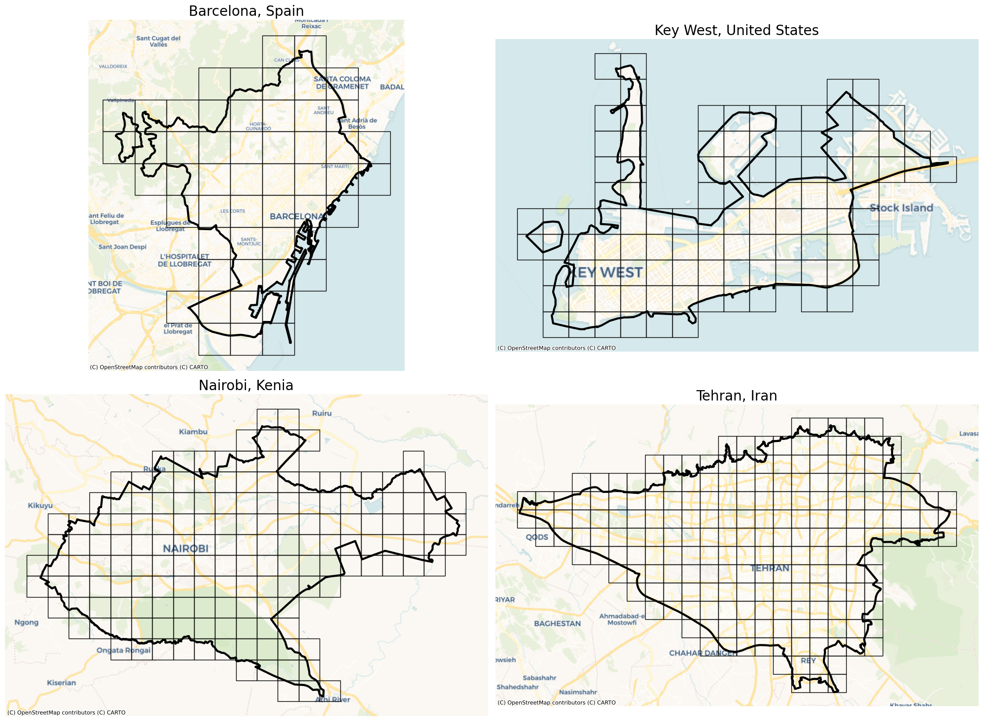
Squares
[16]:
# Creating square tessellation

barcelona_squares = barcelona.squares(14)
key_west_squares = key_west.squares(16)
nairobi_squares = nairobi.squares(14)
tehran_squares = tehran.squares(14)
[17]:
# visualization of square tessellation

cities_squares = [barcelona_squares, key_west_squares, nairobi_squares, tehran_squares]

fig, axs = plt.subplots(2, 2, figsize=(20, 15))

for ax, city_polygon, city_name, city_square in zip(
    axs.flatten(), cities_polygons, cities_names, cities_squares
):
    city_square.to_crs("EPSG:3857").plot(ax=ax, facecolor="none", edgecolor="k", lw=1)
    city_polygon.to_crs("EPSG:3857").plot(ax=ax, facecolor="none", edgecolor="k", lw=3)
    ctx.add_basemap(ax=ax, source=ctx.providers.CartoDB.Voyager)
    ax.set_axis_off()
    ax.set_title(city_name, fontsize=20)

plt.tight_layout()
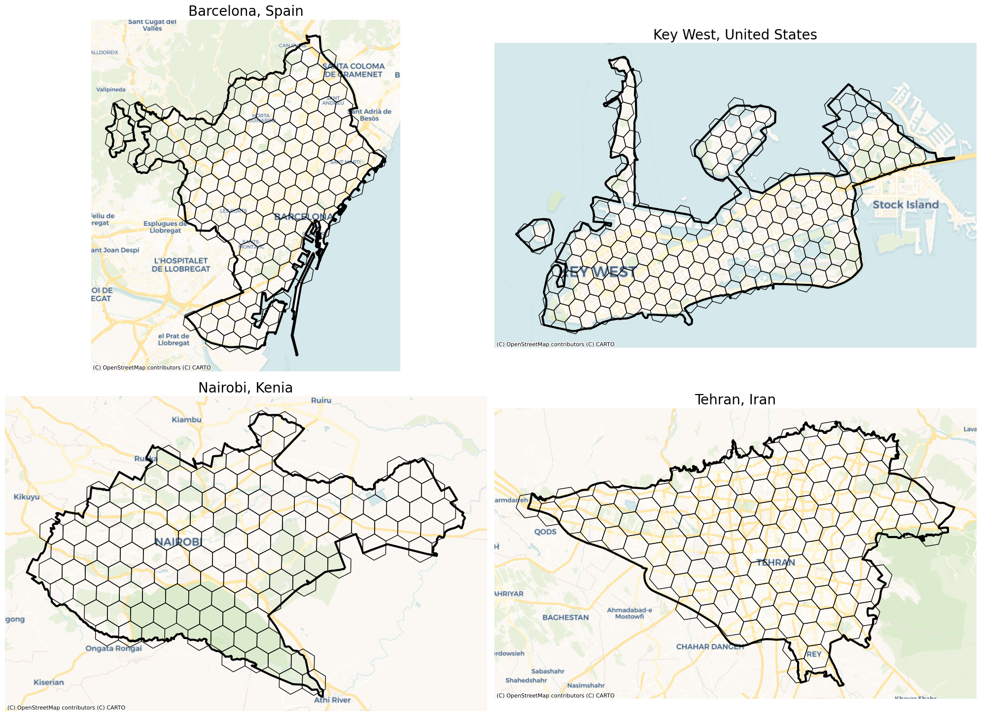
Hexagons
[18]:
# Creating hexagons tessellation

barcelona_hexagons = barcelona.hexagons(8)
key_west_hexagons = key_west.hexagons(9)
nairobi_hexagons = nairobi.hexagons(7)
tehran_hexagons = tehran.hexagons(7)
[19]:
# visualization of hexagons tessellation

cities_hexagons = [
    barcelona_hexagons,
    key_west_hexagons,
    nairobi_hexagons,
    tehran_hexagons,
]

fig, axs = plt.subplots(2, 2, figsize=(20, 15))

for ax, city_polygon, city_name, city_hexagon in zip(
    axs.flatten(), cities_polygons, cities_names, cities_hexagons
):
    city_hexagon.to_crs("EPSG:3857").plot(ax=ax, facecolor="none", edgecolor="k", lw=1)
    city_polygon.to_crs("EPSG:3857").plot(ax=ax, facecolor="none", edgecolor="k", lw=3)
    ctx.add_basemap(ax=ax, source=ctx.providers.CartoDB.Voyager)
    ax.set_axis_off()
    ax.set_title(city_name, fontsize=20)

plt.tight_layout()
Adaptive squares
[ ]:
# Creating adaptive squares tessellation

barcelona_asq = barcelona.adaptive_squares(
    start_resolution=14, poi_categories=["amenity"]
)
key_west_asq = key_west.adaptive_squares(
    start_resolution=15, poi_categories=["amenity"], threshold=40
)
nairobi_asq = nairobi.adaptive_squares(
    start_resolution=13, poi_categories=["amenity"], threshold=150
)
tehran_asq = tehran.adaptive_squares(
    start_resolution=13, poi_categories=["amenity"], threshold=100
)
Voronoi Diagrams
[ ]:
# Creating voronoi tessellation

barcelona_vor = barcelona.voronoi(n_polygons=100, poi_categories=["building"], timeout=180)
key_west_vor = key_west.voronoi(n_polygons=50, poi_categories=["building"], timeout=180)
nairobi_vor = nairobi.voronoi(n_polygons=200, poi_categories=["building"], timeout=180)
tehran_vor = tehran.voronoi(n_polygons=300, poi_categories=["building"], timeout=180)
City Blocks
[ ]:
# Creating city blocks tessellation
# Since it takes a lot of time, we only create the city blocks for two cities.

barcelona_blks = barcelona.city_blocks(n_polygons=500, detail_deg=11)
nairobi_blks = nairobi.city_blocks(n_polygons=500)